
There’s a particular kind of smug satisfaction that comes from rolling up to a postcard view without having broken a sweat. No endless stairs. No ‘moderate to challenging’ trail rating that turned out to be a polite lie. Just your car, a short stroll from the bonnet to the railing, and a horizon that does all the heavy lifting.
The Illawarra Escarpment is built for this. It’s a 500-metre wall of rainforest, sandstone and old volcanic memory that runs the length of Wollongong, and the locals (along with a few clever council planners over the years) have laced it with lookouts you can reach with nothing more than a turn signal and a half-decent playlist.
This is the cheat sheet. Six escarpment views worth the drive, with the practical bits sorted so you can spend less time squinting at Google Maps and more time deciding whether to stop for coffee on the way up or the way down.
Bald Hill Lookout, Stanwell Tops
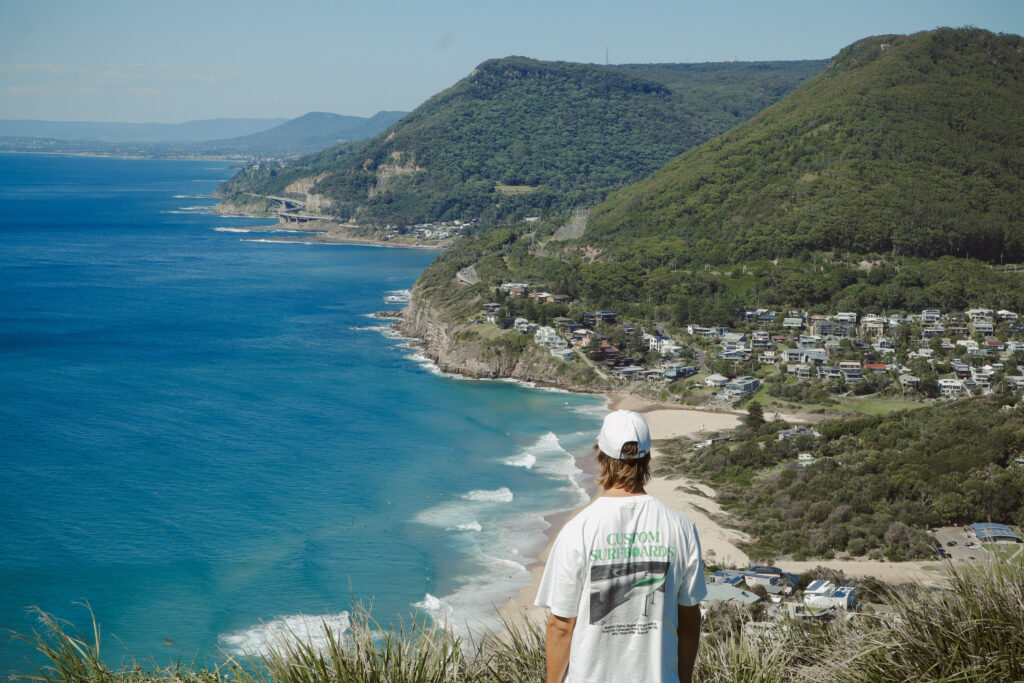
Pull into the car park at Bald Hill and the first thing that hits you is the wind. It comes straight off the Tasman, salt-edged and steady, and it’s the same wind that’s been carrying hang gliders off this clifftop for the better part of a century. Walk out onto the headland and the ground drops away beneath your feet, plummeting down to Stanwell Park Beach curving below. To the south, the coastline runs all the way to Wollongong, beach after beach stitched together by the green spine of the escarpment, with the Sea Cliff Bridge just visible in the distance. To the north, the cliffs of the Royal National Park drop sharply into the sea.
On a good day, you’ll catch the hang gliders launching. They run a few steps along the grass, lift, and then they’re just there, hanging in the air about ten metres above your head, before the thermal catches them and they sail out over Stanwell Park. People stop mid-sentence to watch. It happens every time.
This is the first official stop on the Grand Pacific Drive, and the spot where Lawrence Hargrave was lifted into the air by four box kites on Stanwell Park Beach below in 1894, sparking what eventually became modern aviation. The memorial cairn near the car park has the full story, if you’ve got the time.
Where: 1 Otford Road, Stanwell Tops. About 50 minutes south of Sydney CBD via the M1 and Lawrence Hargrave Drive.
Parking: Free car park right at the lookout, with newer two-hour timed bays in the front section. Get in early on weekends, especially Sundays when the gliders are in full swing.
Facilities: Public toilets, picnic tables, and Flying High Cafe (open 9am to 3pm weekdays, 8am to 3pm weekends) for coffee, snacks and ice cream.
Best time to visit: Early morning for the soft light and an empty car park, or late afternoon for golden hour. November is a special one, with the Festival of Flight marking Hargrave’s first ascent.
Stop nearby: Drop down into Stanwell Park for breakfast or coffee at Pantry at Stanwell Park before or after. If you’ve got time, push on to Coalcliff for a swim in the ocean pool.
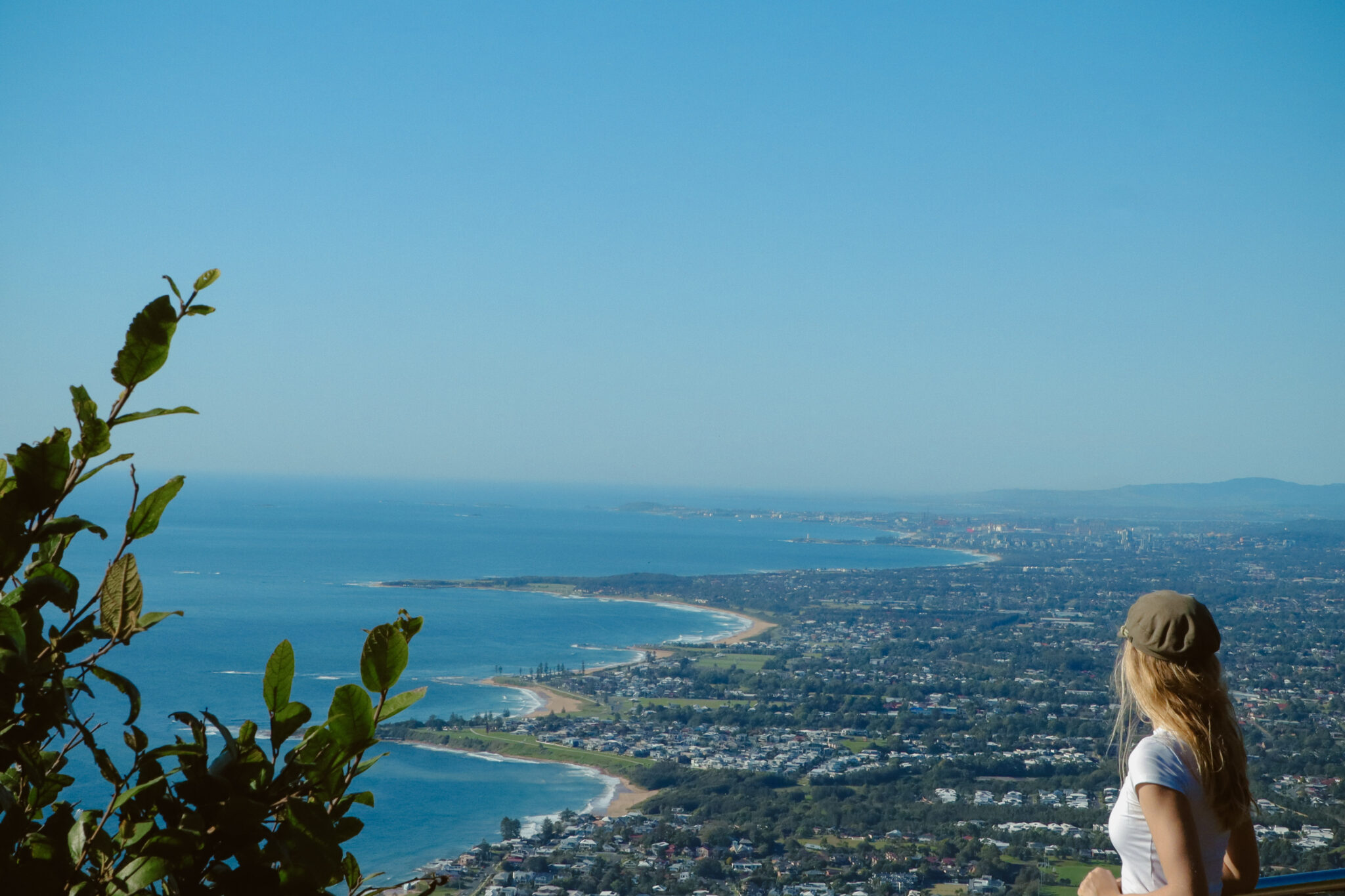
Sublime Point Lookout, Bulli Tops
Step out of the car at Sublime Point Lookout and the view does something to you. It’s the kind of vista where you stop talking for a moment, walk slowly to the edge of the wooden platform, and just look. Seventeen beaches stretch out below in a long, lazy curl, all the way down to Port Kembla and beyond. The escarpment falls away beneath your feet in a tangle of rainforest canopy, and on a clear day, an old sign at the lookout cheerfully claims you can see 40 miles to the horizon. We’re not going to argue.
Linger a minute and the details start to fill in. The faint rumble of waves drifting up from 300 metres below. The occasional flash of a lyrebird scratching through the undergrowth somewhere off the path. The cliff swallows wheeling out over the void. Lean on the railing (there is one here, thankfully) and watch the cloud shadows move across Austinmer and Thirroul. It’s the sort of view that makes you start mentally rearranging your weekend.
A note for the keen: the Sublime Point walking track that climbs the cliff face from Austinmer is currently closed for the remainder of 2026, so driving up is the only way to see this view right now. Honestly, given the track involves 1,100-odd steps and steel ladders, most people will call that a win.
Where: Princes Highway, Bulli Tops. Take the Bulli Tops exit off the M1 and you’re there in two minutes.
Parking: Generous free car park right at the lookout.
Facilities: Toilets, picnic shelters, electric barbecues, and plenty of grassy run-around space. There’s no cafe on site, so bring water and snacks (or save your appetite for the Southern Gateway Centre, see below).
Best time to visit: Mid-morning when the sun’s lighting up the beaches below, or a clear winter day when you can see all the way to Port Kembla and beyond.
Stop nearby: Three minutes south on the Princes Highway, the Southern Gateway Centre is the natural follow-up. Grab a proper feed at Altitude 1148 (with its own clifftop view), an ice cream from Gelato Emporium, and pop into our Visitor Information Centre while you’re there. The team will happily point you towards whatever you’re chasing next.

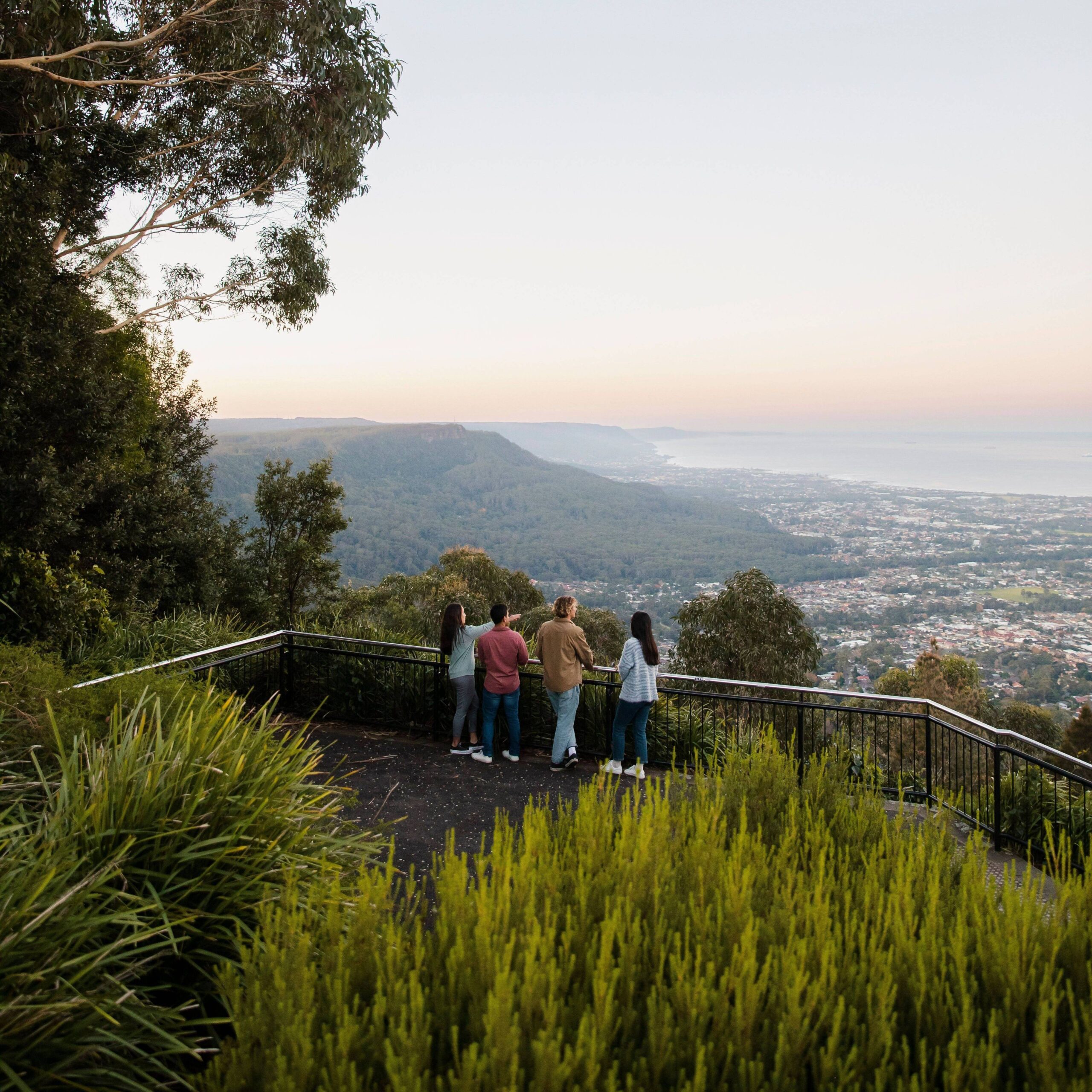
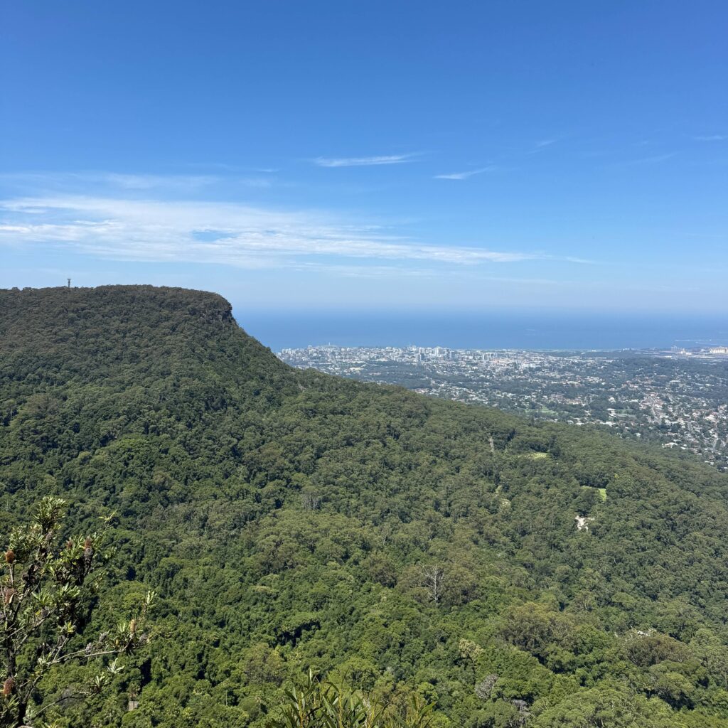
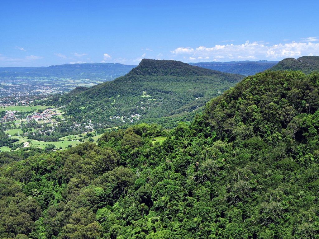
Mount Keira Summit Park & Lookout
The actual drive up Mount Keira is half the experience. The road narrows as you climb, winding through dense rainforest where the canopy closes overhead and the temperature drops a few degrees. Cabbage tree palms lean in from both sides. You’ll catch glimpses of the coast through gaps in the trees, each one bigger than the last, until the road opens out at the summit car park and the full panorama lands in one hit.
Walk to the platform and the whole city sits beneath you. The harbour, the long curve of North Wollongong Beach, the lighthouse on Flagstaff Hill, the Five Islands floating offshore, and the coastline running south past Port Kembla towards Lake Illawarra and the blue smudge of the Shoalhaven beyond. Behind you, the escarpment carries on north and south in a single uninterrupted wall of green. At 464 metres above sea level, you’re high enough that the city sounds disappear and all you can hear is the wind in the eucalypts and the occasional kookaburra cracking up at something only it finds funny.
This is a place of deep significance to the Dharawal people, who know the mountain as Djeera. It features in the creation story of the Five Islands you can see from the platform, and that connection is acknowledged in interpretive signage and the cultural artworks dotted around the park. Stand at the railing at sunset, watch the lights of Wollongong start to flicker on below, and you’ll understand why this spot has held meaning for thousands of years.
Where: Queen Elizabeth Drive, Mount Keira. About 15 minutes from Wollongong CBD up a winding (but completely sealed and signposted) road.
Parking: Large free car park at the summit. The road narrows and winds towards the top, so take it steady and watch for cyclists on the climb.
Facilities: Free electric BBQs, sheltered picnic tables, accessible toilets, and Mount Keira Coffee on site, open 8:30am to 5pm seven days a week. The menu runs from proper coffee and muffins through to burgers, gozleme, chips and gelato, so you can land anywhere from a quick caffeine hit to a full lunch. Dogs are allowed on leash inside the Summit Park itself.
Best time to visit: Sunset is the showstopper here, with the city lights starting to flicker on below. Get there 30 minutes before sundown to claim your spot. It can get blowy at the top, so chuck a jumper in the boot.
Stop nearby: On the way back down, pull in at Wollongong Botanic Garden for a wander (free entry, plenty of shade), or head into the CBD for a coffee or brunch at Lee and Me.
Robertson Lookout, Mount Keira
If Mount Keira Summit is the showstopper, Robertson Lookout is the quiet sleeper hit. You’ll find it tucked off Harry Graham Drive, a kilometre or so past the Mount Keira Road turnoff, and most drivers cruise straight past without ever noticing the small asphalt car park on the side of the road. Their loss.
Park up, follow the concrete path through the trees for 200 metres or so (it’s flat, step-free, and there’s a bench halfway along if you fancy a sit), and the rainforest opens out onto a wooden boardwalk platform with metal handrails. From here, you get what’s quite possibly the best view of Mount Keira itself. The mountain looms straight ahead, massive and green, with rainforest tumbling down to the coastal plain beneath you and a slice of ocean glinting through the canopy beyond.
The air is cooler up here, damp with that rich rainforest smell of leaf litter and wet bark. King parrots flash through the trees below. Somewhere off in the green, a lyrebird is almost certainly working through its impressive catalogue of impressions, which may or may not include a chainsaw and someone’s car alarm. Bring binoculars and you’ll spot kookaburras lined up on branches, plus the odd flash of crimson rosella. Bring a thermos and a sandwich and you’ll likely have the place to yourself.
Where: Off Harry Graham Drive, Mount Keira. From Mount Keira Road, turn onto Harry Graham Drive and the lookout car park is about 1km along on your right.
Parking: Free asphalt car park off Harry Graham Drive, just metres from the path.
Facilities: Picnic tables (including one accessible table along the concrete path), a bench halfway along, and step-free access from the car park to the platform. No toilets, no BBQs, no kiosk. Note: no dogs allowed inside the conservation area.
Best time to visit: Late morning to early afternoon when the sun lights up the rainforest, or anytime you want a peaceful lunch spot without the crowds.
Stop nearby: Pair this one with Mount Keira Summit Park further up the same road or drop into Byarong Park located back down Mount Keira Road towards the city for a proper BBQ setup.
Mount Kembla Lookout
Mount Kembla is the locals’ pick. Quieter than its more famous sibling Mount Keira, this one rewards you with a different angle on the region entirely. Step out of the car at the end of Cordeaux Road and the view swings south, with the wide silver sweep of Lake Illawarra spread out below, and the coastline curving past Windang and Warilla into the distance. The escarpment falls away in front of you in a dense tangle of forest, and the city of Wollongong sits off to your left in the middle distance, somehow looking smaller and more manageable from up here.
There’s a stillness to this spot that the busier lookouts don’t quite manage. The communications tower behind you hums faintly in the wind. A wedge-tailed eagle might cruise past at eye level if you’re lucky. You can hear the very faint thrum of traffic on the highway way down on the plain, but mostly it’s just bush sounds and the breeze moving through the gums. It’s the kind of place where you might end up having a yarn with a Mount Kembla villager who’s wandered up after a coffee or sharing the view with one other car and a couple of cyclists catching their breath at the top of the climb.
The mountain itself holds deep significance for the Wodi Wodi people. They know it as Djembla, meaning wallaby, and it features in many local creation stories. The village below has its own layered history too, including the 1902 mine disaster that claimed 96 lives and still shapes how the community remembers itself.
Where: End of Upper Cordeaux Road, Mount Kembla. About 20 minutes from Wollongong CBD via Mount Kembla village.
Parking: Free roadside car park at the lookout.
Facilities: Honest answer: none. No toilets, no BBQs, no kiosk. Bring what you need.
Best time to visit: Mid to late afternoon when the light hits Lake Illawarra just right. Avoid foggy mornings (you’ll see nothing).
Stop nearby: Drop into the historic Mount Kembla Hotel in the village below for a pub feed and a pint.
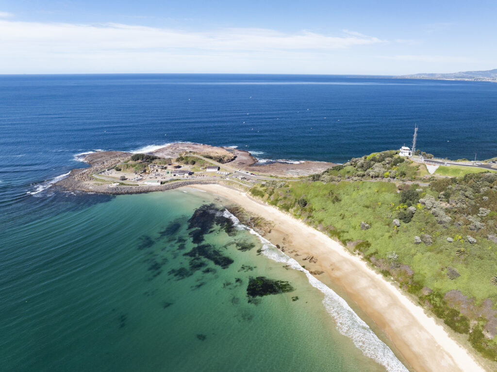
Hill 60 Lookout, Port Kembla
Hill 60 is the one most visitors miss, and frankly, that’s their loss. This grassy headland rises sharply above Fisherman’s Beach and Port Kembla, jutting out into the ocean like the prow of a ship, and from the top you get a 360-degree view you won’t find anywhere else in Wollongong. Ocean to the east, stretching to the horizon. Port Kembla Beach curling away to the north, the Five Islands floating offshore close enough to feel like you could swim out, and (depending on which way you face) the striking industrial silhouette of the steelworks to the west, all chimneys and steam against the green wall of the escarpment behind.
What makes Hill 60 different is the texture of the place. Concrete WWII gun emplacements squat in the grass, half-swallowed by the elements, and you can walk between them and run your hand along the cool concrete arches. The bunkers themselves were carved into the sandstone during the war to protect the steelworks, and while the underground tunnels are closed to the public, the surface fortifications are open to wander. The wind here is constant, salt-heavy and a touch wilder than the escarpment air. Sit on the grass at dusk and watch the steelworks light up below you, then turn around and watch the moon rise over the Pacific. There’s nowhere else in Wollongong quite like it.
Hill 60 also holds deep cultural significance for the Wadi Wadi people. The headland is dotted with shell middens, traditional fishing sites and burial places, and was used as a fish-spotting lookout for a successful Aboriginal fishing enterprise that supplied local and Sydney markets up until the 1940s. The site is listed on the NSW State Heritage Register for both its Aboriginal cultural heritage and its WWII military history.
It’s also one of the best whale-watching spots in Wollongong between May and November. Find a perch, scan the horizon, and wait. The whales will usually do the rest.
Where: Military Road, Port Kembla. About 15 minutes south of Wollongong CBD.
Parking: Free car park near the summit lookout, with a second lower car park closer to the WWII tunnel entrances and beach access.
Facilities: BBQs at one of the lookout points, but no toilets at the summit. Drive down to Port Kembla Beach for amenities.
Best time to visit: Sunrise is exceptional here, with the light coming straight off the ocean. Whale-watching season (May to November) is the other peak time. Dusk delivers a particularly atmospheric photo as the steelworks light up.
Stop nearby: Port Kembla’s main street has had a quiet glow-up in recent years. Wander down Wentworth Street for a casual feed, a coffee, or a beer at one of the local pubs.
A Few Things Worth Knowing Before You Go
Pack a jumper. The escarpment sits a fair chunk higher than the coast, and it’s almost always cooler and breezier up top. What feels balmy on the beach can feel brisk on Bald Hill.
Check the weather. A clear day at the bottom doesn’t always mean a clear day at the top. Cloud can sit on the escarpment for hours when the coast is bathed in sunshine. If you’re driving up for the view, look up first.
Take your rubbish with you. Most of these lookouts are inside national park or conservation land. Bins fill up fast on weekends, so be prepared to take your wrappers home with you.
Mind the wildlife. Lyrebirds, king parrots, kookaburras and the occasional goanna are regulars. They’re not pets. Don’t feed them.