
Wollongong’s coastline is filled with magnificent lookouts nestled atop the Illawarra Escarpment. View the coastline from any vantage point-and believe us, it’s pretty spectacular!
Bald Hill Lookout, Stanwell Tops
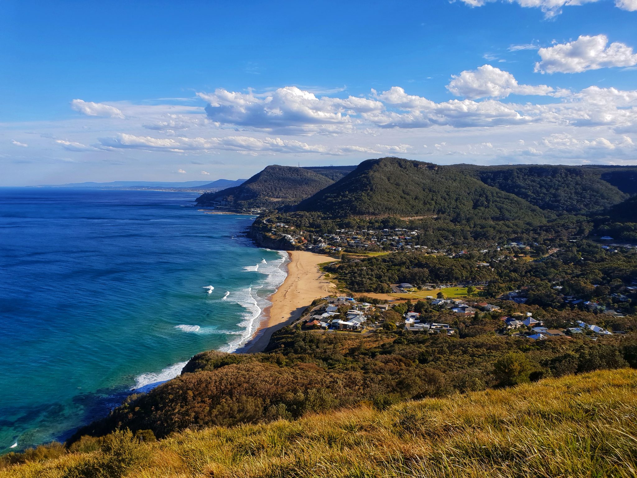
One of the region’s most iconic lookouts, Bald Hill offers sweeping views over the ocean and along the coastline south to the Sea Cliff Bridge and Wollongong. A world renowned hang gliding location where adventure seekers take off over the cliff and are swept up as they fly over the coastline like a bird.
It was on the beach below Bald Hill where Lawrence Hargrave, an Australian pioneer of flight, experimented with box kites in the early part of the 20th century. A memorial cairn dedicated to him has been erected at the peak of the hill near the car park.
Bald Hill is located on Lawrence Hargrave Drive and is also the first official stop along the spectacular 140km Grand Pacific Drive. The Grand Pacific Drive is accessible heading south from Sydney on the M1 Motorway or via the Royal National Park (tip: follow the Grand Pacific Drive directional road signage).
Facilities include public toilets, free parking (timed parking at part of the carpark) and a café.

Southern Gateway Centre, Bulli Tops
The Southern Gateway Centre is perfectly perched on the Illawarra Escarpment at Bulli Tops with magnificent views over the Wollongong coastline. It’s easily accessible for those heading south towards Wollongong on the M1 Motorway and is open 7 days a week with public amenities, free parking, visitor information, gifts and souvenirs.
The Centre marks the Gateway to Wollongong and the South Coast, enjoy stunning 180 degree ocean and escarpment views from the viewing platform. Drop into the Visitor Information Centre for expert local knowledge, enjoy a meal at the adjoining restaurant/café Altitude 1148 or a freshly made Gelato at the Gelato Emporium.

Sublime Point Lookout, Bulli Tops
Sublime Point Lookout is easily accessible heading south from Sydney on the M1 Motorway, providing one of the best vantage points over Wollongong and Illawarra region. Offering 180-degree views, this lookout really captures the beauty of the Illawarra Escarpment and South Pacific Ocean.
The lookout is accessible 7 days a week during daylight hours and offers free parking, toilets & barbeques.

Mt Keira Lookout, Mt Keira
Mt Keira is a local landmark of Wollongong, towering 463.9 metres high and casting its protective shadow over our beautiful city. It’s located just 4 kilometres northwest of Wollongong CBD, it forms part of the Illawarra escarpment and provides sweeping views over Wollongong.
Keira is an Indigenous Australian term meaning large lagoon or high mountain. The Dharawal Aboriginal people called it Djera, meaning wild turkey. The first maps of the area called it Keera, later adding the i. The mountain is usually pronounced Kee-rah.
The natural beauty of Mt Keira gives an unspoiled backdrop to the City of Wollongong. It’s home to the popular 5.5km Mt Keira Ring Track, a walking track which passes through varied terrains and forests of the Illawarra Escarpment, starting and finishing in a scenic picnic spot.
Mt Keira lookout is located on Mt Keira Road and is accessible 7 days a week during daylight hours. Barbeque facilities and public toilets are available.

Mt Kembla Lookout, Mt Kembla
After visiting Mt Keira lookout, you can continue on tourist drive 11 to Mt Kembla which is a charming historical mining village.
Kembla is an Aboriginal word meaning “wild game abundant” or “plenty of game”. The Dharawal Aboriginal people called the area “jum-bullah” or “Djembla” which means Wallaby.
The lookout offers amazing views of Lake Illawarra and the coastline. For hikers, it’s a 30-minute walk uphill from Mt Kembla village and is the starting point for the 5.3km Ring and Summit tracks. If you just want to enjoy the view without the hard work, free car parking is available at the lookout which you can access via Cordeaux Road.
There are no facilities at this lookout.

Hill 60 Lookout, Port Kembla
Hill 60 lookout is one of the lesser known lookouts in the region but nevertheless still offers spectacular views up and down the coastline, and more specifically Port Kembla beach.
Just below the lookout are beaches fished commercially by local Aboriginal fishermen up until the 1940’s, the area still has numerous Aboriginal shell middens and artefacts scattered along its shores.
Deep beneath this scenic lookout, lies a series of fortifications which were established at the beginning of World War II. These fortifications housed large guns which were put in place to protect the vital industrial centre of Port Kembla. Although there are no longer any large guns here, the concrete bunkers can be clearly seen. These bunkers are connected to a series of underground tunnels, and in fact, the area is honeycombed with tunnels. These tunnels are not open to the public.
Hill 60 Lookout is accessible off Military Road, Port Kembla.
